1. Ponmudi Highlands — Mist Valleys, Sky-Islands & Shola Secrets
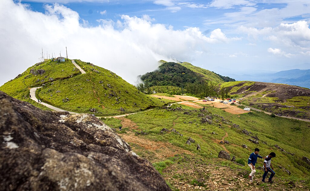
Perched along the southern spine of the Western Ghats, Ponmudi represents one of Kerala’s most atmospheric and least-commercial hill environments. While it sits about 60 km from Thiruvananthapuram city, Ponmudi remains a quiet ecological refuge—favoured by international travelers who prefer cloud-wrapped landscapes, winding ridge roads, and biodiversity-rich shola forests rather than crowded hill stations.[1]
The hill station sits at roughly 1,100 m (≈3,600 ft) above sea level and forms part of a larger ecological network connecting shola patches, the Kallar river basin, and nearby protected areas such as Peppara Wildlife Sanctuary. The terrain includes grassland domes, serrated ridgelines, and deeply forested valleys—classic “sky-island” features of the southern Western Ghats.[2]
Ecology & Photo Targets
Ponmudi’s mosaic of montane grasslands and shola forest supports a range of Western Ghats species:
- Endemic & forest-edge birds: several Western Ghats specialists and hill-forest passerines;
- Butterflies & orchids: seasonal blooms and large butterfly species appear after rains;
- Stream amphibians: unique frogs and wet-zone herpetofauna in the Kallar microcatchment.
The nearby Peppara catchment influences Ponmudi’s hydrology and helps maintain perennial streams and small waterfalls that are ideal for long-exposure waterfall photography and misty valley frames.[3]
Best Time to Visit
November–February are the best months for clear vistas, cool temperatures, and dawn bird activity. The monsoon (June–September) converts Ponmudi into a dramatic, cloud-filled landscape (excellent for waterfall and moody monsoon photography), although heavy rains can limit trail access and local services.[1][5]
Top Photo Locations
- Upper Ponmudi viewpoint — sunrise panoramas and layered ridgelines;
- Golden Valley & Kallar stream — small cascades, pools, and forest reflections;
- Shola fringe trails — macro and canopy-edge compositions;
- Varayadumotta ridge (visible from viewpoints) — serrated skyline suitable for wide-angle frames.
How to Reach & Practicalities
Ponmudi is approximately 55–61 km by road from Thiruvananthapuram (Trivandrum) city; the last stretch climbs steeply along a scenic two-lane road with multiple hairpin turns. The nearest railhead and airport are in Thiruvananthapuram; road transport (taxis or self-drive) is the most practical option for photographers who need early starts. Basic guesthouses, homestays and a few eco-lodges are available; staying closer to Vithura/ Kallar shortens morning travel to viewpoints.[1][2]
Responsible Travel Notes
- Stick to marked trails and avoid entering restricted forest pockets without permits.
- Carry rain protection and silica packs for gear—high humidity and sudden showers are common.
- Respect local communities and avoid drone use in protected or restricted zones unless authorised.
- Support local homestays and forest-edge businesses to promote community conservation.
2. Vattavada Frost Plains & High-Altitude Farms

Courtesy: Department of Tourism, Govt of Kerala
Tucked away in the eastern rain-shadow of the Western Ghats, Vattavada is among Kerala’s most distinctive lesser-known landscapes — a high-altitude agricultural village that combines mist-clad hills, terraced farms, fruit orchards and far-reaching vistas. Despite being just ~45 km from the busy hill station Munnar, Vattavada feels like a different world: cool climate, rural tranquillity, and a patchwork of farms and forest edges that appeal especially to photographers, slow-travelers, and eco-tourists. [1]
Geography, Climate & Unique Setting
Vattavada lies within the high ranges of the Western Ghats in Idukki district, at elevations ranging roughly from ≈1,450 m to 2,700 m above sea level[2]. Because of its location in the rain-shadow zone, the area enjoys a cooler, more temperate climate compared to the Ghats’ windward slopes — a factor that allows cultivation of vegetables and temperate fruits rarely possible elsewhere in Kerala. [3]
The altitude and unique climate make Vattavada ideal for producing strawberries, carrots, cabbage, garlic, beans, and even temperate-climate fruits like plums and peaches — crops uncommon in most of Kerala. [4]
Why Vattavada Qualifies as a Hidden Natural Wonder
- High-range farms & patchwork landscapes: Terraced vegetable farms and orchards interspersed with forest patches, offering a visual mosaic unusual for Kerala hills. Perfect for wide-angle sunrise/sunset frames and rural-landscape photography.
- Clear night skies & refreshing climate: Because of elevation and low light pollution, Vattavada offers crisp night skies — a treat for astrophotographers and travellers seeking a calm hill retreat. [5]
- Quiet rural life & farming culture: Unlike commercial hill stations, Vattavada retains a calm village ambience, traditional agriculture, and farm-to-table produce — a living example of sustainable high-range farming landscapes.
Main Attractions & Experiences
- Strawberry and vegetable farms: Walk through local farms, pick fresh produce (when in season), and experience farm life close up. [6]
- Scenic viewpoints & valley vistas: Viewpoints near the village reveal rolling hills, patchwork farms and misty valleys — spectacular during sunrise or cloudy monsoon mornings. [7]
- Nature walks and nearby forest treks: The village lies close to forest belts; short nature walks or gentle treks offer chances to glimpse Ghats flora, butterflies, and forest-edge fauna. [3]
- Peaceful homestays & farm stays: Homestays among vegetable farms or village settlements offer authentic experiences — fresh local meals, rural ambience, and easy access to fields and hills.
Best Time to Visit
The ideal period to visit Vattavada is between October and March. During this time: the climate remains cool and crisp; strawberry and vegetable farms flourish; clear skies and good visibility favour landscape photography. [8] Avoid heavy monsoon months, unless you are prepared for unpredictable weather and limited farm-access.
How to Reach & Practicalities
Vattavada is roughly 45–50 km from Munnar. The most common route is via Mattupetty → Top Station → the rolling ghats. The last leg involves narrow, winding roads — hiring a local jeep or taxi is recommended for safety. [9]
The nearest major railway station is about 130–160 km away, and the nearest airport is Cochin International Airport. Due to the rural nature of Vattavada, public transport is limited; self-drive or local taxi/jeep is most practical if you aim for early-morning or golden-hour photography. [3]
Responsible & Respectful Travel Notes
- Respect the farming fields — avoid unauthorised entry or harvesting without permission. Seasonal crops are the livelihood of local families.
- Support local homestays and vegetable-farm based stays to encourage sustainable tourism rather than resort-style commercialization.
- Respect local culture and village norms — many families follow traditional patterns and value modesty and privacy.
- Maintain cleanliness — waste management is essential, especially as rural infrastructure is limited and nature must be protected.
3. Agasthyarkoodam Foothills & Peak — Sacred Hills, Biodiversity & Trekker’s Paradise
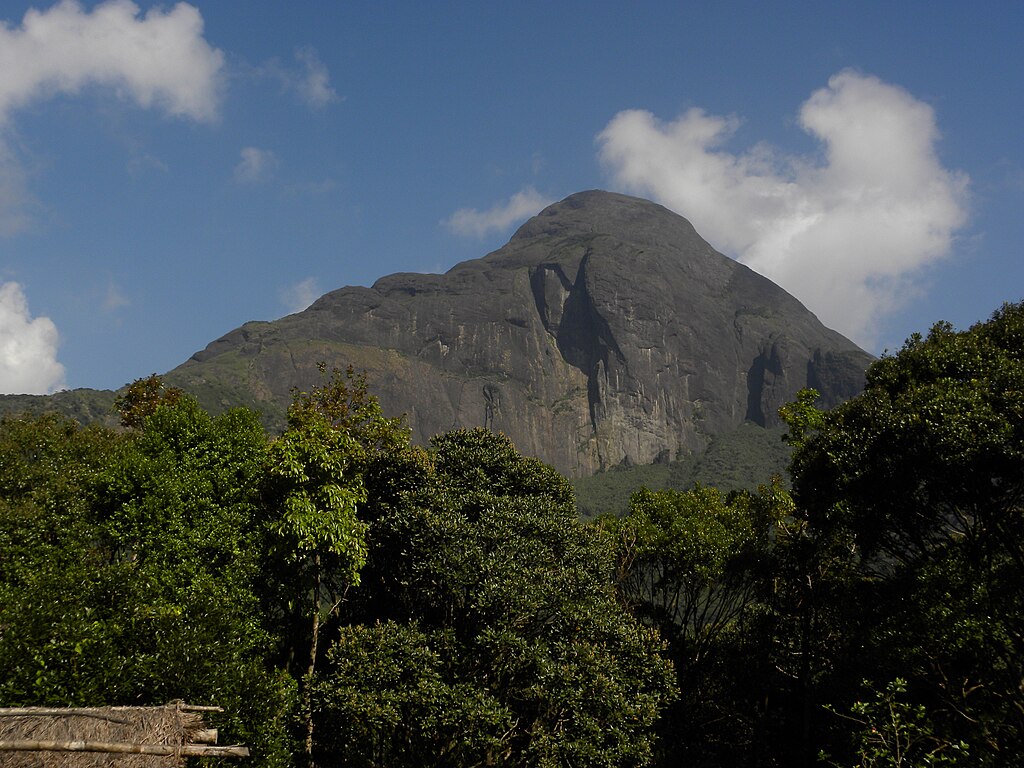
Standing at 1,868 metres above sea level, Agasthyarkoodam is one of Kerala’s — and the southern Western Ghats’ — most iconic yet under-appreciated natural wonders. Part of the Agasthyamala Biosphere Reserve, this peak and its surrounding forest-hills combine deep evergreen forests, rare medicinal flora, sacred significance, and a challenging trek — making it a magnet for global nature lovers, birdwatchers, writers and eco-travelers. [1]
Why Agasthyarkoodam Qualifies as a Hidden Natural Wonder
- Extensive biodiversity & medicinal flora: The region is home to over 2,000 species of plants — including rare herbs, orchids, mosses and ferns — many with high medicinal value under traditional Ayurvedic knowledge systems.[2]
- Rare wildlife & endemic species: The forests shelter mammals such as the Nilgiri langur, sloth bear, and Nilgiri tahr; a rich bird-life; and many forest-edge species. [3]
- Dramatic landscape transitions: The trekking route ascends through moist deciduous forest to evergreen sholas, grasslands, misty high-altitude meadows and finally rocky ridges — offering ever-changing scenery in a single hike. [4]
- Cultural & spiritual significance: The summit holds a small shrine to the sage Agastya, giving the peak sacred status among local communities and pilgrims. [5]
Best Time & Accessibility — When and How to Visit
The trekking season for Agasthyarkoodam opens in January and continues through March. During this period, weather is most stable, forest paths are accessible, and biological activity (birds, flora) is high. [6] The trek begins at Bonacaud (forest picket station), approximately 60–70 km from Thiruvananthapuram city — accessible by road, with airport and railhead at Trivandrum. [2][7]
What Makes the Trek Unique — Landscape, Flora & Wildlife
- Rainforest to mountain ridge gradient: Within a 2-day trek you move from low-altitude semi-evergreen forest to high-altitude grasslands and rocky ridges — offering photographers and naturalists a microcosm of Western Ghats’ altitudinal biodiversity.
- Medicinal plant diversity: Known for rare herbal species and endangered plants, the area has been a traditional source for Ayurvedic herbs and wild-crafted medicinal flora. [8]
- Bird & animal sightings: Bird watchers may spot endemic and threatened species; mammals including langurs, tahr, sloth bears, elephants — though sightings require patience and respect for habitat. [9]
Trekking Guidelines, Permits & Responsible Travel Ethics
Entry to the peak is strictly regulated by the forest department under the biosphere-reserve rules. Trekking is permitted only during official windows (January–March), with limited daily quota, mandatory guides, and eco-tourism regulations (no plastic, no night trekking, no off-trail movement, etc.). [1][6]
- Respect all forest regulations: permit, group trekking, no littering, no collection of plants.
- Use eco-friendly gear; avoid loud flash photography or disruptive noises.
- Respect local tribal and forest communities living on foothills; seek permission and tread lightly in culturally sensitive zones. [10]
Suggested 3-Day Itinerary for International Travelers
- Day 1: Arrive Thiruvananthapuram → Travel to Bonacaud check-post; permit formalities; begin trek to Athirumala base camp (forest walk through lowland forest).
- Day 2 (summit push): Pre-dawn hike through evergreen forest → grasslands → ridge → reach summit for sunrise; return to base camp.
- Day 3: Return trek to Bonacaud; optional visit to nearby forest-edge villages for cultural experience or side-trip to nearby waterfalls / lowland forests.
Why Agasthyarkoodam Resonates with Global Nature Travelers
In a world where wilderness is shrinking, Agasthyarkoodam offers a rare, regulated wilderness experience: biodiversity, cultural heritage, spiritual layers, and raw mountain terrain—all within reach of Kerala’s transport infrastructure. For photographers, birders, conservation-minded travelers and seekers of silence, it stands as one of Kerala’s most primal natural wonders.
4. Kakkayam & Ripon–Kanthanpara: Reservoir Valleys, Waterfalls & Forest Edges of North Kerala
In the northern stretch of Kerala’s Western Ghats lies a hidden region that combines forested hills, a tranquil reservoir, waterfalls, and remote valleys — a region that remains mostly off mainstream tourist maps. Kakkayam, with its dam reservoir, dense woodland, and proximity to the Malabar Wildlife Sanctuary, along with the forest-edge waterfalls and hills around the Ripon–Kanthanpara region, offers a rare blend of adventure, serenity, and natural beauty. For global nature-travelers who favour offbeat paths, this cluster represents Kerala’s “wild edge.”
Kakkayam — Reservoir, Forests & Waterfalls
The heart of this region is the Kakkayam Dam & Reservoir, built on the Kuttiyadi river under the hydroelectric project. Surrounded by forested slopes and Ghats hills at roughly 750 m above sea level, the reservoir reflects misty peaks and forest walls — a dreamy scene for landscape lovers and photographers.[1]
Visitors can explore the reservoir by boat, operated under the state’s hydel-tourism initiative. The boat ride reveals hidden forest waterfalls, forest-edge valleys, and occasionally wildlife glimpses along the shorelines — elephants, bison, deer, and other forest dwellers — making the experience both peaceful and thrilling.[2]
Forest Trails, Rock Climbing & Adventure
Beyond the reservoir lies a network of forest trails, rock outcrops, and forest hills. One can trek or climb to vantage points for panoramic views of the valley, waterfall streams, and dense forest canopy. The region also includes forest waterfalls such as Urakkuzhi Waterfalls and Ambalappara Waterfall — reachable only via forest-stream approaches or boat rides on the reservoir. These hidden waterfalls offer raw, unspoiled scenes for adventurous travellers.[3]
Why It Qualifies as a Hidden Natural Wonder
- Remote yet accessible: Although connected to Kozhikode, the forest-edge roads and requirement for boat/jeep make the region feel remote and wild.
- Landscape diversity: Reservoir reflections, hill slopes, waterfall gorges, dense forest — all within a compact area.
- Wildlife corridor: Part of the Malabar Sanctuary belt, increasing chances of seeing mammals and forest birds during early morning or boat safaris.[4]
- Off-season magic: Post-monsoon months (October–February) present clear skies and lush forest, while monsoon heightens waterfall flow and greenery — offering different moods depending on travel style.
Practical Info: When & How to Visit
The best window for Kakkayam is November to April. During this time, the reservoir stays calm and accessible; forest trails are safer; boat rides operate regularly; and waterfall flows are moderate enough for safe exploration. Boat-service and hydel-tourism operations are managed by the state authority. [5]
For logistics: the nearest major railhead is Kozhikode, about 50–60 km from the dam; the airport is Calicut International. From Kozhikode, travelers can hire jeep/taxi or use local transport up to the forest entry. Given the forested terrain and occasional trail closures (especially during monsoon or wildlife alerts), it’s advised to check current status with local eco-tourism office before planning. [6]
Ripon–Kanthanpara Region & Waterfall Escape
Moving eastwards into the hilly ranges of Wayanad lies the region around Kanthanpara Waterfalls, accessible from Meppadi or Kalpetta. The waterfall drops about 30 m, and its forest-edge pool and surrounding greenery — especially after rains — offer a peaceful retreat for travellers wanting less-crowded waterfall experiences. [7]
Though small and modest compared to big tourist waterfalls, Kanthanpara and neighbouring forest valleys around the Ripon–Kanthanpara area combine forest walks, gentle waterfalls, and rural-mountain ambience — ideal for travellers who seek calm, mid-altitude nature escapes without heavy trekking or commercial tourism bustle.
Best Season & Travel Tips for Kanthanpara
The ideal time to visit up to Kanthanpara is October to May, especially just after monsoon when pool waters are clean and waterfalls still have moderate flow. Avoid heavy monsoon months when rock surfaces and trails become slippery and dangerous.[8]
- Wear water-proof sandals or trekking shoes with grip if you plan to walk near falls or forest paths.
- Carry mosquito repellent and basic first-aid — forested hills in Wayanad sometimes have leeches or uneven terrain.
- Respect local land — many waterfall access paths pass through rural farms or village roads; permission or local guidance is ideal.
- Always check weather and forest-department advisories; waterfall flows and safety conditions can change rapidly after rains.
Why This Cluster Matters for Global Travellers
Together, Kakkayam and the Ripon–Kanthanpara region represent a seldom-photographed, under-documented side of Kerala — a landscape of reservoirs, waterfalls, forest edges, and remote valleys. For a global traveller seeking offbeat, tranquil, and diverse natural experiences — from calm water reflections to forest gorges and waterfall pools — this region offers a powerful mix of adventure, serenity, and ecological richness.
5. Meenmutty Waterfalls (Wayanad) & Nelliyampathy Hills — Waterfalls, Hills & Offbeat Escapes
5.1 Meenmutty Waterfalls, Wayanad — Wild Cascade in the Ghats’ Heart
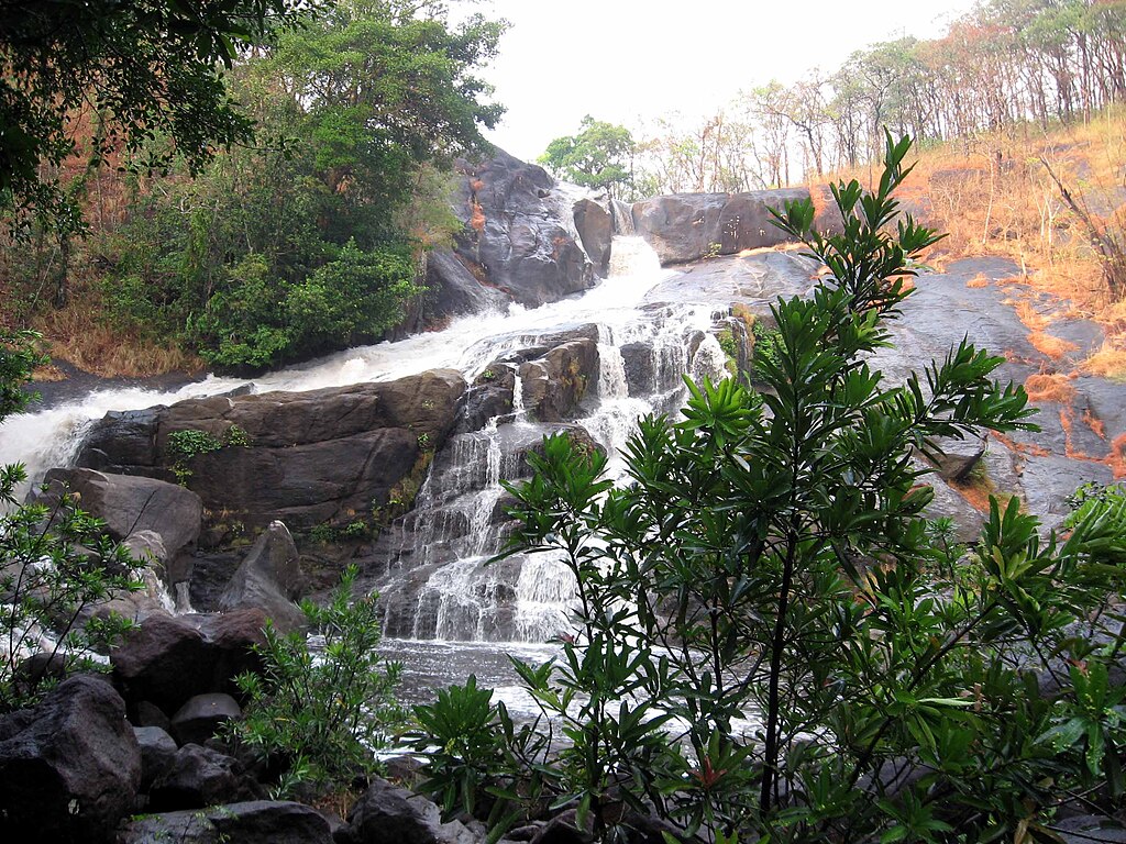
Nestled deep within the forest-covered hills of Wayanad lies Meenmutty Waterfalls, a dramatic three-tiered cascade that remains among Kerala’s most powerful yet under-publicised waterfalls. The falls drop roughly 300 m through dense jungle, over boulder-strewn terrain — forming dramatic plunges followed by calm pools ideal for photography, reflection and trekking-style adventure. [1]
What makes Meenmutty special is its blend of raw wilderness and manageable access. From the entrance point, a ~2-km forest/rock-trail (partly through tea-estate fringes, partly dense forest) leads to the base. The trail ends in a shallow pool; continuing over boulders and ropes leads to higher tiers and vantage points — offering views over hills, forest canopy and distant slopes. [2]
Best Time to Visit & Visitor Tip
The ideal season is October to February — post-monsoon or winter — when flows are strong enough to create spectacular cascades but not dangerously swollen. During monsoon (June–Sept), heavy flow and slippery rocks make visits risky. Always check local forest-department or tourism advisories before planning. [3]
What to Do: Activities & Photography
- Trekking & jungle walk — The 2 km trail itself is scenic, passing through tea estates, streams, and forest edges.
- Water-pool dip & natural bathing — The base pool is relatively safe in lean-flow periods; always check water-flow and avoid deep zones.
- Long-exposure waterfall shots & wide-angle landscape frames — Especially early morning or late afternoon, when light filters through forest canopy.
- Birding & butterfly spotting — The forest-edge ecosystem supports many endemic bird and insect species, creating opportunities for macro and wildlife photography.
How to Reach — Logistics
Meenmutty is ~29 km from Kalpetta (Wayanad district headquarters). The nearest railhead is at Kozhikode; the closest airport is Calicut International Airport. From Kalpetta, hire a car or taxi; some local buses go toward Meppadi/Thondernad and drop near the entrance gate. Trek entry is during 9 AM–5 PM; avoid arrival post-3 PM to ensure safe return before dusk. [4]
Safety & Responsible Travel Notes
- Do not attempt waterfall pool swimming during heavy flow or immediately after rain.
Rocks are slippery; zigzag through marked paths and avoid off-trail shortcuts. - Carry only what you need — plastic waste and littering are major threats to fragile forest ecosystem.
Use eco-friendly gear, avoid flash-lights near water-birds, and maintain silence to respect wildlife. - Consult forest-department notices for landslide or closure alerts — the area is prone to heavy rain surges.
5.2 Nelliyampathy Hills — Quiet Highlands of Palakkad for Offbeat Hill-Plains & Forests

Courtesy: Department of Tourism, Govt of Kerala
Far from Kerala’s crowded hill resorts lies Nelliyampathy Hills, a lesser-known highland region in Palakkad district. Characterised by rolling hills, forest-edge plains, spice and tea estates, misty mornings and remote villages, Nelliyampathy remains off the tourist radar for many — but offers a rare glimpse into silent highlands, panoramic ridgelines, and unspoiled nature. [5]
The hills range roughly between 1,200 to 1,800 metres above sea level, and the slopes are covered with a mix of tropical evergreen forest patches, plantation zones (tea, rubber, pepper) and open valleys — creating a patchwork landscape ideal for landscape photography, trekking, birding and slow travel.
Why Nelliyampathy is a Hidden Gem
- Less crowded than mainstream hill stations: Unlike Munnar or Wayanad, Nelliyampathy draws fewer tourists — offering solitude and quiet hills.
- Mist-clad ridges & sunrise-sunset panoramas: The higher altitudes produce misty mornings and dramatic cloud-scapes — great for wide-angle hillside compositions.
- Mixed forest & plantation ecology: The mosaic of natural forest patches and managed plantations creates diverse habitats — rewarding for birders and nature photographers.
- Local village & spice-estate culture: Rural settlements at hill fringes — interact with locals, enjoy traditional Kerala highland cuisine, and see everyday life contrasted against forest backdrops.
When to Visit & What to Expect
The best period to visit Nelliyampathy is November to March, when rainfall is lighter, skies are clearer, and visibility is high. Misty dawns, crisp air, and manageable roads make hill-plains accessible. Avoid heavy monsoon peaks (June–August) when landslides and road-closures are possible. [6]
Suggested Activities & Photo Ideas
- Sunrise ridge photography: Capture rolling hills, valley layers and morning mist from viewpoints or estate ridges.
- Forest-edge trails & birdwatching: Explore small evergreen patches and managed plantations for endemic birds and forest-edge species.
- Village-estate life portraits: Engage with spice-estate workers, capture rural landscapes with plantation backdrops.
- Slow travel & homestay stays: Stay in local homestays for immersive experience — traditional food, quiet nights, natural sounds; ideal for travel writers and long-stay travellers.
Access & Practical Logistics
Nelliyampathy is about 60–70 km from Palakkad town. The most common route passes through Keral’s midlands, ascending via winding forest/hill roads. Accommodation is limited to a few eco-lodges, guesthouses and homestays — there are no large resorts. Visitors should carry their own supplies, especially if staying longer. Mobile connectivity may be patchy, especially in forest-clad zones. [7]
Responsible & Respectful Travel Guidelines
- Avoid flash floods — do not trek or swim after heavy rainfall; hills may become hazardous.
- Respect private plantations and local settlements — take permission before entering estates or photographing people.
- Use sustainable and local services — support small homestays, local guides, and avoid commercial exploitation of fragile hills.
- Leave no trace — carry back all waste, avoid disturbing forest patches, and travel in small groups to minimise impact.
7.Gavi Eco-reserve
Gavi, situated inside the Periyar Tiger Reserve in Pathanamthitta district, is one of Kerala’s best examples of sustainable eco-tourism. The region combines dense evergreen forests, misty hills, cardamom plantations, and a serene lake where visitors can enjoy guided canoeing. Wildlife sightings include elephants, Nilgiri langurs, barking deer, giant squirrels, and more than 250 species of birds. Unlike commercial destinations, Gavi strictly controls visitor entry, ensuring a quiet wilderness experience with minimal ecological disturbance.
Best Time to Visit
November to March offers the most pleasant weather with cool mornings and clear wildlife sightings. Avoid June–August if you prefer dry trails, as monsoon rainfall may restrict activities.
How to Reach
Gavi can be accessed via Kumily or Vandiperiyar. Permission from the Kerala Forest Development Corporation (KFDC) is mandatory before entering. The forest road from Vandiperiyar to Gavi is scenic but restricted, and visitors must report at the check-post with valid passes.
Travel Tips
- Carry original ID proof for entry verification.
- Night stay is limited to KFDC-approved eco-lodges and tents.
- Avoid loud noise and always follow guide instructions during forest treks.
- Mobile network is weak—download offline maps beforehand.
8. Paithalmala Ridge
Paithalmala, located in Kannur district near the Kerala–Karnataka border, is a dramatic ridge that opens into rolling meadows, shola forests, and sweeping views of Coorg’s highlands. The trekking trail is moderately challenging but rewarding, with mist-covered pathways, rare orchids, butterflies, and excellent opportunities for sunset photography. The region’s protected shola-grassland ecosystem makes it one of the finest trekking landscapes in northern Kerala.
Best Time to Visit
October to February is ideal for trekking, with cool weather and clear skies. Monsoon (June–September) offers the most atmospheric views but trails can be slippery.
How to Reach
Paithalmala is around 55 km from Kannur town. The last motorable point is the Paithal Valley base, from where a 3–3.5 km forest trek takes you to the ridge. Jeep services are available from nearby villages.
Travel Tips
- Carry water as there are no shops on the trekking trail.
- Wear good shoes; leeches are common during monsoon months.
- Drone flying may require forest permission—check local guidelines.
- The ridge gets foggy after 3 PM; start early for clear views.
9.Mankulam Elephant Corridor
Mankulam, located near Munnar, is a peaceful forest region known for its active elephant movement routes. Spread across river valleys, damp forests, and quiet tribal hamlets, the region offers exceptional wildlife photography opportunities and meaningful community-based tourism experiences. Its untouched charm, forest roads, and cascading waterfalls like Nambeemkallu and Perumankuthu make Mankulam a calm alternative to crowded Munnar.
Best Time to Visit
September to February is the best period for cool weather and wildlife movement. Avoid late evenings in forest routes as elephant herds travel frequently after dusk.
How to Reach
Mankulam is accessible from Munnar (22 km) via the Munnar–Mankulam forest road or from Adimali via Kallar. Jeep services operated by local residents are recommended for deeper forest exploration.
Travel Tips
- Never approach elephants or block their crossing paths—maintain safe distance.
- Prefer guided jeep rides; some areas have no paved roads.
- Best visited during daytime; avoid driving alone at night.
- Carry cash as network and digital payment availability can be limited.
10.Chinnar Rain-shadow Valleys

Image Credit: Tourism Department
The Chinnar Wildlife Sanctuary, on the Kerala–Tamil Nadu border, lies within the Western Ghats’ rain-shadow zone, creating a unique dry scrub ecosystem unlike any other region in Kerala. With thorn forests, rocky hills, open grasslands, and riverine patches, Chinnar supports species such as the Grizzled Giant Squirrel, star tortoises, spotted deer, and a wide variety of raptors. The sanctuary’s landscape is ideal for long nature walks, wildlife observation, and studying dry-forest ecology.
Best Time to Visit
December to March provides the most comfortable weather. The dry season also offers better chances to spot animals near water sources.
How to Reach
Chinnar is located on the Marayoor–Udumalpet road, around 60 km from Munnar. Kerala Forest Department organizes guided trekking, watchtower visits, and stay options inside forest huts with advance booking.
Travel Tips
- Carry sunscreen and a cap—the region is significantly hotter than Munnar.
- Book watchtower stays early; they offer exclusive sunrise views of the rocky valleys.
- Water availability is limited—carry enough before entering the sanctuary.
- Photography of the Grizzled Giant Squirrel requires patience and a long lens.
11. Malakkappara–Sholayar Range
The Malakkappara–Sholayar forest belt stretches along the borders of Thrissur, Palakkad, and Tamil Nadu, forming one of the most scenic and biologically rich forest corridors in the Western Ghats. The region connects parts of the Anaimalai–Parambikulam landscape and is known for deep forests, tea estates, wide valleys, and frequent wildlife sightings—including elephants, Malabar hornbills, and gaur. The journey itself is a highlight, with winding roads passing through untouched rainforest patches and mist-covered plantation slopes.
Best Time to Visit
October to April offers clear, pleasant days ideal for long forest drives and photography. Monsoon is beautiful but prone to landslides; travel only if weather conditions are stable.
How to Reach
Malakkappara can be reached from Athirappilly (50 km) via one of Kerala’s most scenic forest routes or from Valparai in Tamil Nadu. The entire stretch passes through restricted forest zones—entry may close during heavy wildlife activity or rain.
Travel Tips
- Start early; the forest gates often close by evening.
- Avoid stopping at random spots—elephant crossings are frequent.
- Carry snacks and water; facilities are rare between Athirappilly and Malakkappara.
- Perfect route for landscape photographers—use wide lenses for valley views.
Plan Your Trip to Kerala’s Hidden Natural Wonders
Ready to explore Kerala beyond the usual tourist trail? From misty hilltops at Ponmudi and serene waterfalls at Kanthanpara to the remote dry forests of Marayoor and high-altitude Kurinjimala Sanctuary, Kerala is full of offbeat wonders waiting for your adventure.
Book Comfortable Stays Nearby
Whether you prefer cozy homestays, boutique resorts, or eco-lodges amidst the forest, you can find the perfect accommodation via Booking.com. For user reviews and insights on hotels, guesthouses, and local lodgings, check TripAdvisor.
Flights & Travel Connections
Plan your flights to Kerala efficiently using Kiwi or Trip.com for competitive fares and flexible schedules. In case of delays or flight issues, check your entitlements with Airhelp or Compensair.
Tours & Experiences
Enhance your Kerala experience with curated tours — from private houseboat cruises in the backwaters to guided nature walks. Discover the best local experiences via Viator Kerala Tours.
Travel Money & Extras
Ensure smooth travel and currency conversions with reliable options like WayAway, and book budget-friendly tickets or last-minute flights via CheapoAir or Aviasales.
- Kerala Tourism – Ponmudi Hill Station official info [1]
- HiKerala.info – Vattavada Travel Guide [2]
- Kerala Forest & Wildlife Dept – Agasthyarkoodam Sanctuary [3]
- Silent Valley National Park – Official Site [4]
- Kakkayam Reservoir & Eco Tourism – Wayanad.com [5]
- Kerala Tourism – Thoovanam Waterfalls [6]
- Ripon Estate & Kanthanpara Falls – JustKerala.in [7]
- Wayanad Tourism – Meenmutty Waterfalls [8]
- Gowayanad.info – Meenmutty Hiking [9]
- Kerala Tourism – Nelliyampathy Hills [10]
- Nelliyampathy Travel & Climate Guide [11]
- Kurinjimala Sanctuary – Kerala Forest Dept Notification [12]
- HiIdukki.in – Kurinjimala Overview [13]
- Chinnar Wildlife Sanctuary – Kerala Tourism [14]
- Chinnar WLS – Trawell.in [15]
- Marayoor Sandalwood Forest & Dolmens – Munnar Insider [16]
- Brahmagiri Wildlife Sanctuary – Wikipedia [17]