A Hydrological Engine, Not Just a Chain of Lakes
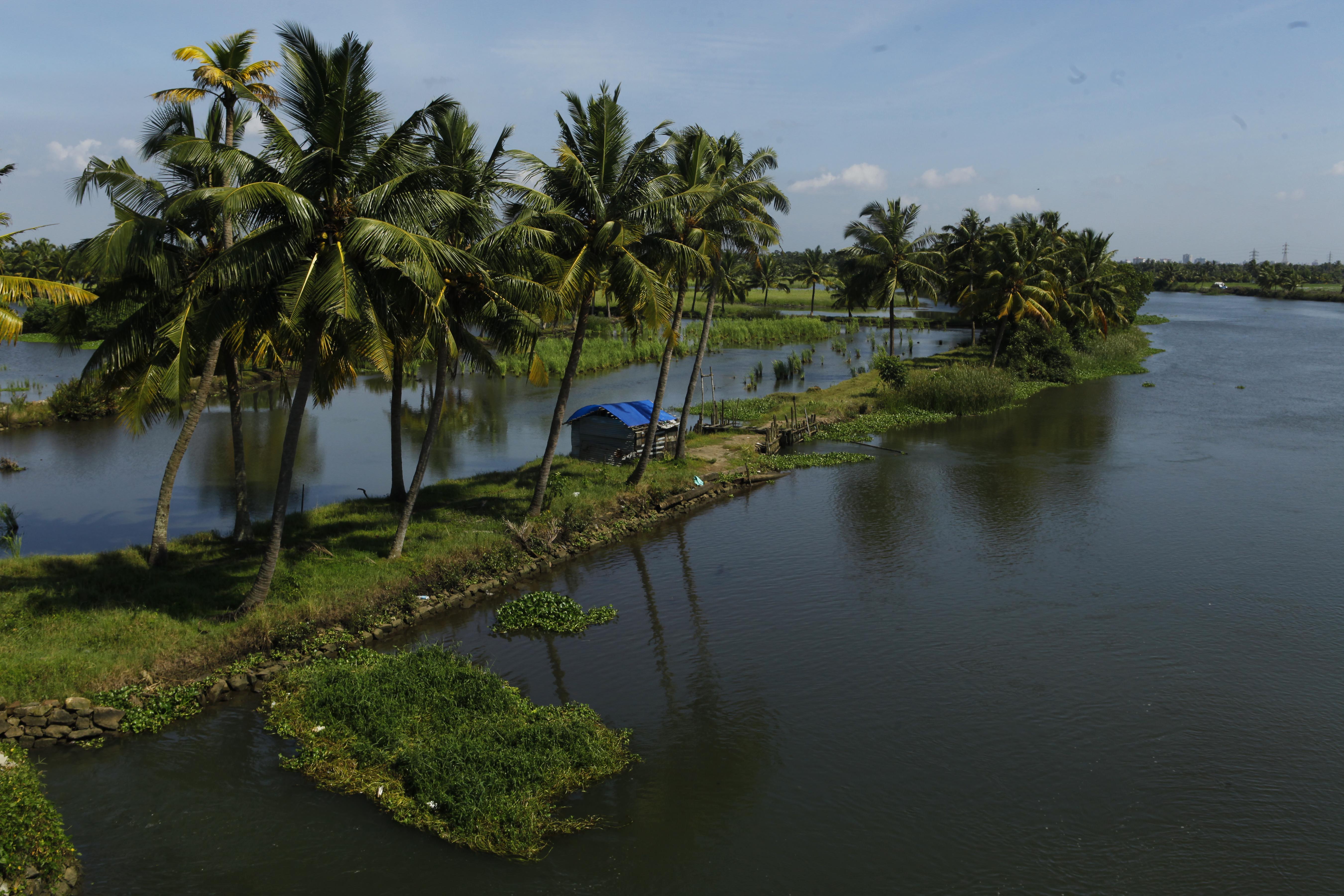
Tourism brochures tend to describe Kerala's backwaters as a serene chain of lakes and canals. In reality they form one of South Asia's most complex freshwater–brackish wetland systems — stretching nearly 900 km along the coast, functioning simultaneously as a hydrological engine, a biodiversity hotspot, and a cultural landscape shaped by centuries of adaptation.
Unlike a conventional river system, the backwaters are a fusion of river outflow, tidal inflow, monsoon flooding, coastal sedimentation and human engineering — producing a mosaic of freshwater zones, brackish stretches, mangrove belts, flooded paddy fields and riparian settlements, each with its own ecological and cultural rhythm. For the communities living here, this isn't a tourist attraction — it's transportation, farming, fishing, ritual and micro-economy, all keyed to the pulse of the water.
How the Backwaters Were Formed
The Kerala backwaters aren't a single water body but a vast interconnection of lagoons, lakes, canals, rivers and estuaries. Geologically, they formed through coastal sedimentation: waves and shore currents deposited sand and silt along the coast, creating low barrier islands and sand-spits. As rivers descending from the Western Ghats reached the coast, their mouths were blocked by these sediment ridges, producing shallow estuaries, lagoons and kayals — the Malayalam term for backwater lagoons.
Vembanad Lake — The Largest Basin
Vembanad Lake, extending nearly 96 km, is the largest and most ecologically significant backwater body in Kerala. Fed by ten major rivers, it functions as a vast monsoon reservoir regulating water, sediment and nutrient flow across much of central Kerala. Kumarakom Bird Sanctuary sits on its eastern shore, and Punnamada Lake — a sub-basin — hosts the Nehru Trophy Boat Race.
Ashtamudi — The Palm-Shaped Estuary
Ashtamudi Lake in Kollam district — often called the gateway to the backwaters — is a palm-shaped estuarine wetland whose name means "eight-coned" in Malayalam, describing its branched topography. Its short-neck clam fishery holds India's first Marine Stewardship Council (MSC) certification, awarded in 2014 — only the third fishery in Asia to receive it, and a genuinely significant conservation milestone for a community-run, small-scale fishery.
Freshwater–Brackish Gradients
What makes the ecosystem so productive is its dynamic freshwater–brackish gradient. Between June and October, monsoon rivers flood the system with freshwater, triggering plankton blooms and fish spawning. From January to May, water levels fall and tidal exchange increases, letting seawater intrude inland — creating brackish zones where prawn, clam and estuarine fish complete their life cycles. This alternating salinity is the engine behind the system's productivity.
Human Engineering — Canals, Bunds and the Thanneermukkom Bund
Over centuries, communities reshaped this hydrology with canals, bunds, polders and sluice gates. The most consequential intervention is the Thanneermukkom Bund across Vembanad, built to block saltwater intrusion and protect the Kuttanad rice basin. It enabled large-scale farming, but also caused real ecological disruption:
- Decline in fish species dependent on saltwater migration cycles
- Invasion of freshwater weeds blocking canal navigation
- Reduced natural flushing of agricultural pollutants and sediment
- Altered downstream hydrology affecting downstream biodiversity
This dual character — naturally formed waterways further reshaped by human intervention — makes the backwaters a genuine example of a co-created socio-ecological landscape, where ecology, livelihood and history are inseparable.
Ecology & Biodiversity
The backwaters sit at the meeting point of three systems — riverine freshwater habitats, tidal brackish estuaries and coastal wetlands — which explains the scale of biodiversity they sustain.
"The backwaters are not just a scenic attraction but a living socio-ecological landscape that has sustained diverse forms of life — human and non-human — for thousands of years."
Kerala Nature Vibes — Ecology Research NotesAquatic Flora
Submerged aquatic vegetation plays a foundational role — Vallisneria spiralis ("tape grass") carpets large stretches of Vembanad Lake, forming nurseries for juvenile fish and prawns. In shallower margins, blue water lily and sedge grasses stabilise sediment and reduce erosion, while reed beds trap silt and absorb nutrients. Invasive water hyacinth (Eichhornia crassipes), by contrast, spreads aggressively and blocks sunlight — researchers estimate a meaningful share of backwater vegetation cover has been altered by invasive species and hydrological disruption.
Mangroves
Rhizophora apiculata, Avicennia marina, Bruguiera gymnorrhiza and Excoecaria agallocha survive in pockets along Vembanad, Vallarpadam, Kadamakkudy and Ashtamudi. Mangroves function as ecological buffers — stabilising muddy shores, absorbing pollutants, serving as nurseries for shrimp, fish and crabs, and storing carbon. Documented mangrove loss around Kochi and Vembanad between 1957 and 2019 has been substantial, driven mainly by land reclamation and urban expansion.
Fish, Crustaceans & Molluscs
More than 150 fish species have been recorded across the backwater system, alongside numerous prawn, crab and mollusc species.
| Common Name | Scientific Name | Habitat Zone | Significance |
|---|---|---|---|
| Pearl Spot (Karimeen) | Etroplus suratensis | Freshwater/Brackish | Kerala's state fish; iconic food fish |
| Asian Sea Bass | Lates calcarifer | Estuarine | Commercial & sport fishing |
| Flathead Mullet | Mugil cephalus | Brackish/Marine | Key livelihood species |
| Giant Freshwater Prawn | Macrobrachium rosenbergii | Freshwater | Aquaculture & fisheries |
| Short-neck Clam | Paphia malabarica | Estuarine (Ashtamudi) | MSC-certified sustainable fishery |
| Mud Crab | Scylla serrata | Mangrove/Estuarine | Export fishery commodity |
Migratory Birds
The backwaters fall along the Central Asian Flyway, one of the world's major bird migration corridors. Wetlands around Kumarakom, Kuttanad, Pathiramanal Island and Kadamakkudy serve as wintering grounds for dozens of migratory species; birdwatching surveys have documented more than 180 species across the Vembanad-Kole wetland complex.
🦅 Key Species to Look For
Migratory: Garganey, Northern Pintail, Western Marsh Harrier, Black-tailed Godwit, Whiskered Tern, Common Sandpiper. Resident: Purple Heron, Little Cormorant, Oriental Darter, Common Moorhen, multiple kingfisher species.
Farming, Fishing and Life Shaped by Water
Villages here formed along narrow strips of reclaimed wetland, where homes and paddy fields sit only a few feet above water level. Canals do the work roads do elsewhere: school boats ferry children, floating markets move through villages, and boats provide emergency transport during monsoon flooding.
Kuttanad — Farming Below Sea Level
Kuttanad, often called the rice bowl of Kerala, is one of very few places in the world where organised farming happens roughly 2 to 2.5 metres below sea level. Farmers build earthen bunds and polders, manually pump out water, and grow traditional rice varieties adapted to semi-saline soils.
During monsoon season, many shift to pokkali farming — an indigenous rotational method alternating saline-resilient rice with prawn culture in the same poldered fields. No chemical inputs are used: prawns fertilise the soil, and rice residues feed the next prawn cycle. It's internationally recognised as a Globally Important Agricultural Heritage System by the FAO.
🌾 Why Pokkali Farming Matters
Zero chemical inputs by design, not certification. Carbon-neutral — prawn biomass replaces synthetic fertiliser. Preserves traditional saline-resilient rice genetics. Recognised by the FAO. Under real pressure from urban encroachment, with active revival programmes in Ernakulam district.
Fishing Communities
Fishing communities — mainly Dheevara and Mukkuva groups — depend on a mix of marine, estuarine and freshwater species. Traditional techniques remain in daily use: vallom fishing with narrow dugout canoes at dawn, Chinese fishing nets (cheena vala) at river mouths, shore-based cast netting, and clam collection at Vembanad Lake, a livelihood for thousands of families.
Canoe Routes as Daily Highways
Before modern roads, the backwaters were Kerala's inland navigation system — and for many villagers, they still are. Country canoes remain the practical way to reach markets, temples and clinics along routes like Alappuzha–Kainakary–Nedumudy and Vaikom–Thanneermukkom. For travelers, these same routes offer the most genuine backwater experience available, well beyond what a houseboat can reach. A guided shikara boat ride through Alleppey's village canals follows much the same idea — a smaller, quieter craft reaching stretches a houseboat simply can't.
Traditions Tied to the Water
- Kettuvallam craftsmanship — coir-stitched boats built without a single nail
- Coir spinning by women along canal edges, a centuries-old cottage industry
- Backwater cuisine — pearl-spot fry, toddy-paired dishes, yam preparations
- Champakkulam Moolam — Kerala's oldest snake boat race, held on the Pampa River
Threats to a Fragile System
Shrinking Wetlands
The Vembanad-Kol system has shrunk substantially since the 1950s as land reclamation for housing, tourism and agriculture fragments critical habitat.
Houseboat Pollution
Diesel leaks, greywater discharge and plastic from uncertified vessels have caused algal blooms and fish mortality in busy tourist corridors.
Salinity Intrusion
Sea-level rise and erratic monsoons are increasing salinity intrusion in Kuttanad, breaching bunds and damaging pokkali fields.
Overfishing
Juvenile harvesting during peak breeding seasons has reduced native fish populations, particularly pearl spot and freshwater shrimp.
Invasive Weeds
Water hyacinth chokes canals, blocking sunlight and oxygen. Clearing operations offer only temporary relief without addressing root causes.
Sand Mining
Uncontrolled sand mining causes bank erosion and reduced canal depth, trapping pollutants and hampering navigation.
What's Actually Working
- The Vembanad Lake Samrakshana Samithi — fisher groups monitoring fish sanctuaries and enforcing seasonal bans
- Kumarakom's Responsible Tourism initiative — linking tourism revenue directly to farmers and artisans
- Pokkali revival programmes supporting saline-resilient organic farming
- Participatory wetland mapping involving universities and local research centres
- Ashtamudi's MSC certification — proof that community-led, small-scale fisheries can meet international sustainability standards
Canoe Routes Worth Knowing
Canoes reach narrow capillary canals houseboats can't access — kitchen gardens, village ferry points, coir-making sheds, early-morning fish markets.
- Kuttanad's ultra-narrow sub-canals — dawn and dusk rides past duck farms and paddy bunds, guided by community operators who directly benefit from the trip
- Kumarakom's village-mangrove trail — through bird sanctuary edges and fisherman settlements beside Vembanad Lake; silent paddling matters here to avoid disturbing nesting birds
- Alleppey's heritage canal belt — the historic commercial canals once used for rice and spice, past toddy tappers and coir-craft families; a popular way to see this stretch today is a shikara boat ride with a village and canal tour
- Ashtamudi to Munroe Island — a quieter, almost entirely community-run circuit through mangrove patches and limestone canals
Responsible Backwater Travel
- Choose certified eco-guides and village-run canoe services over hotel-arranged packages that bypass local operators
- Carry reusable water bottles — avoid plastic during canal rides, where waste enters the water directly
- Keep noise low near mangroves, reed beds and bird colonies, especially October–February during peak migration
- Don't ask a canoeist to approach nesting areas or active fishing nets
- Support local farmers by buying island-grown vegetables, spices or coir products
- Book DTPC-certified houseboats only — they meet bio-toilet and waste-management standards
🛶 Alleppey Shikara Boat Ride
A small-boat alternative to the big houseboats: a shikara ride through Alleppey's narrower village canals, with stops to see canal-side homes, coir-making and daily backwater life up close.
🏡 Planning a Backwater Stay
Compare eco-lodges, homestays and houseboats in Alleppey, Kumarakom and Kuttanad, check recent reviews, and browse structured multi-day circuits with local guide support.
✈️ Flying Into Kochi or Thiruvananthapuram
Compare fares to Kochi (COK) or Thiruvananthapuram (TRV), and consider flight protection since monsoon-season delays aren't uncommon on this route.
Some links on this page are affiliate links — if you book through them, we may earn a small commission at no extra cost to you. See our Affiliate Disclosure for details.
Common Questions About the Backwaters
References
- Asian Waterbird Census (2022). Wetland Bird Population Trends in India. Bombay Natural History Society.
- Bombay Natural History Society (2020). Wetland Census Report.
- Cardoso, A.C. et al. (2019). "Brackish Water Ecosystems: Structure and Function." Journal of Estuarine Science.
- Central Marine Fisheries Research Institute (2021). Status of Fisheries in Vembanad and Ashtamudi Wetlands.
- Department of Environment, Government of Kerala (2020). Kerala Wetland Inventory.
- Zoological Survey of India (2017). Fish Faunal Diversity in Kerala's Backwater Systems.
- Marine Stewardship Council / ICAR (2014). Ashtamudi Short-Neck Clam Fishery MSC Certification.
- Kerala State Council for Science, Technology & Environment (2022). The Hydrological Function of Thanneermukkom Barrage.
- Kerala Agricultural University (2018). Pokkali: The Climate-Resilient Farming System of Coastal Kerala.
- National Wetland Inventory & Assessment (2019). State Wetland Atlas: Kerala. Government of India.
- UNESCO Ramsar Secretariat (2011). Vembanad-Kol Wetland (Ramsar Site) Profile.
- WWF India (2020). Vembanad Lake Environmental Status Report.